I have a PostGIS table of polygons where some intersect with one another. This is what I'm trying to do:
- For a given polygon selected by id, give me all of the polygons that intersect. Basically,
select the_geom from the_table where ST_Intersects(the_geom, (select the_geom from the_table where source_id = '123')) - From these polygons, I need to create a new polygons such that intersection becomes a new polygon. So if polygon A intersects with polygon B, I will get 3 new polygons: A minus AB, AB, and B minus AB.
Any ideas?
Answer
Since you said you get a group of intersecting polygons for each polygon you're interested in, you may want to create what is referred to as a "polygon overlay".
This isn't exactly what Adam's solution is doing. To see the difference, take a look at this picture of an ABC intersection:
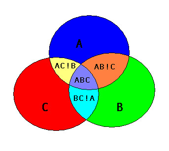
I believe Adam's solution will create an "AB" polygon that covers both the area of "AB!C" and "ABC", as well as an "AC" polygon that covers "AC!B" and "ABC", and a "BC" polygon that is "BC!A" and "ABC". So the "AB", "AC", and "BC" output polygons would all overlap the "ABC" area.
A polygon overlay produces non-overlapping polygons, so AB!C would be one polygon and ABC would be one polygon.
Creating a polygon overlay in PostGIS is actually pretty straightforward.
There are basically three steps.
Step 1 is extract the linework [Note that I'm using the exterior ring of the polygon, it does get a little more complicated if you want to correctly handle holes]:
SELECT ST_ExteriorRing(polygon_col) AS the_geom FROM my_table) AS lines
Step 2 is to "node" the linework (produce a node at every intersection). Some libraries like JTS have "Noder" classes you can use to do this, but in PostGIS the ST_Union function does it for you:
SELECT ST_Union(the_geom) AS the_geom FROM (...your lines...) AS noded_lines
Step 3 is to create all the possible non-overlapping polygons that can come from all those lines, done by the ST_Polygonize function:
SELECT ST_Polygonize(the_geom) AS the_geom FROM (...your noded lines...)
You could save the output of each of those steps into a temp table, or you can combine them all into a single statement:
CREATE TABLE my_poly_overlay AS
SELECT geom FROM ST_Dump((
    SELECT ST_Polygonize(the_geom) AS the_geom FROM (
        SELECT ST_Union(the_geom) AS the_geom FROM (
            SELECT ST_ExteriorRing(polygon_col) AS the_geom FROM my_table) AS lines

        ) AS noded_lines
    )
)
I'm using ST_Dump because the output of ST_Polygonize is a geometry collection, and it is (usually) more convenient to have a table where each row is one of the polygons that makes up the polygon overlay.


No comments:
Post a Comment