I have a question about GIS terminology - what is the difference between grid and raster and grid and lattice - in theory??
I thought, that raster is regular network and value is in the cell and the grid have its value in node. In this case I don´t understand what meaning have a lattice? Is the same as a grid?
Or grid is raster with value in one of the corner??
What is more confusing are some pictures, which describes difference between grid and lattice - http://www.geog.ubc.ca/courses/geob370/notes/interpolation/grid_vs_lattice.png or http://www.innovativegis.com/basis/mapanalysis/Topic18/Topic18_files/image005.jpg
In case of MATLAB example: http://www.mathworks.com/help/releases/R2013b/matlab/ref/meshgrid_ex.gif grid looks like lattice!
Answer
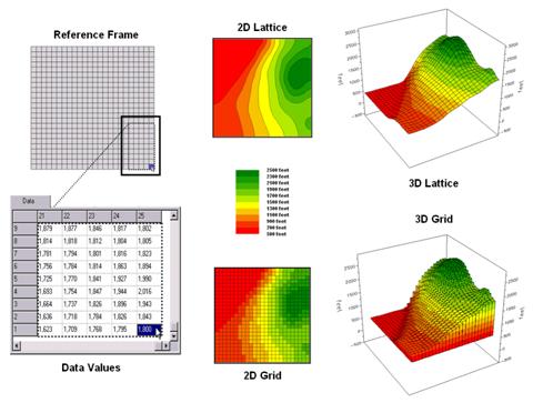
The problem is that the names sometimes change depending on the software. Below you find the definitions from ESRI.
RASTER = A spatial data model that defines space as an array of equally sized cells arranged in rows and columns, and composed of single or multiple bands. Each cell contains an attribute value and location coordinates. Unlike a vector structure, which stores coordinates explicitly, raster coordinates are contained in the ordering of the matrix. Groups of cells that share the same value represent the same type of geographic feature.
-> In other words, it is a grid of pixels (used for most of the "field" represention).
LATTICE = A representation of a surface using an array of regularly spaced sample points (mesh points) that are referenced to a common origin and have a constant sampling distance in the x and y directions. Each mesh point contains the z-value at that location, which is referenced to a common base z-value, such as sea level. Z-values for locations between lattice mesh points can be approximated by interpolation based on neighboring mesh points.
-> In other words, it is a grid of points (often used for LIDAR data).
note that GRID is also the native raster format of ESRI. And rasters are called GRID in QGIS.
In any case, they are all based on array of regularly spaced items, so there representation is very similar. The big difference is that raster is of "matrix" type while lattice is of "vector" type.
To generalize a little bit, within Matlab, the container is always of matrix type. And a vector in Matlab is only a subtype of matrix, while in GIS it means something completely different ("vector is something you can draw with a pen").
Concerning the location of the value, for points it is obvious, and for raster it is either at the center of the cell or defined for the entire cell. BUT the extent definition may vary depending on the software (again). The upper left coordinate is sometimes the upper left of the pixel, and sometimes the center of the pixel: this can cause shifts of 1/2 pixels if you are not aware.
No comments:
Post a Comment